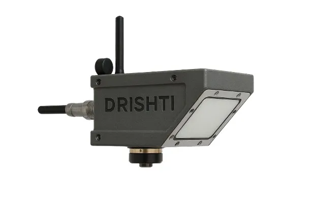
CLM-CVDR05
Radar + Vision Based River Monitoring System
Integrated system for non-contact radar-based monitoring with integrated vision and real-time data systems for critical infrastructure and disaster management.
Engineered for Mission Critical Reliability
Feature 1
61 GHz radar level sensor
Feature 2
24 GHz velocity sensor
Feature 3
Integrated camera monitoring
Feature 4
Built-in data logger
Feature 5
WiFi + Bluetooth
Feature 6
Multi-network (4G / LoRa / NB-IoT)
Feature 7
Solar powered (15-day backup)
Feature 8
IMU-based calibration
Technical Specifications
Detailed breakdown of CLM-CVDR05's capabilities
System Overview
- Water level monitoring (radar)
- Surface velocity measurement (radar)
- Visual monitoring (camera)
- On-device data logging
- Remote telemetry
Comprehensive Component Specifications
Radar specs
Velocity specs
Camera specs
Data logger
Communication
Power
Environmental
Detailed System Requirements
3. Radar Water Level Monitoring
The water level monitoring system shall meet the following minimum requirements:
The radar sensor shall provide continuous measurement of river water level without direct contact with water.
- Measurement Principle: Non-contact radar
- Operating Frequency: Approximately 61 GHz FMCW radar
- Measurement Range: Minimum 0–30 meters
- Accuracy: ±1 mm or better
- Resolution: ≤ 1 mm
- Sampling Frequency: Configurable up to 1 sample per second
- Mounting: Bridge / pole / structure mount
- Output Interfaces: RS-485 / MODBUS / digital interface
4. Surface Flow Velocity Monitoring
The system shall support radar-based surface flow velocity measurement.
The velocity sensor shall operate in non-contact mode and shall be capable of operating reliably during turbulent flow conditions.
- Measurement Principle: Doppler radar
- Operating Frequency: 24 GHz
- Beam Aperture should be less than 12°x25°
- Velocity Range: 0.02 – 20 m/s
- Accuracy: ±1–2 % of measured value
- Resolution: ≤ 0.01 m/s
- Installation Height: Up to 20 meters above water surface
- Should provide signal quality information
5. Optical River Monitoring Module
Each monitoring station shall include an integrated optical monitoring camera module within the same sensing unit as the radar sensor for continuous visual observation of river conditions.
The optical monitoring module shall be integrated with the radar monitoring unit as a single device assembly. Additionally, the system should support vision-based river condition assessment such as surface flow pattern observation and discharge estimation support where applicable.
- Camera Type: Industrial monitoring camera
- Resolution: Minimum Full HD (1080p)
- Lens: Adjustable / wide-angle lens
- Field of View: Approx. 100–120° horizontal
- Image Capture: Automatic image capture at predefined interval (minimum 1 image per hour)
- Housing: Outdoor weatherproof enclosure integrated with radar unit
- Real-time viewing of river conditions through remote access
- Live streaming capability when required by the control center
- Remote camera tilt adjustment for improved monitoring of river cross-section
- Periodic automated image capture and transmission to central server
- Visual documentation of river flow conditions, debris movement, and flood events
6. Integrated Data Logger
Each monitoring station shall include a built-in industrial data logging unit integrated within the monitoring device.
The system shall support local data storage on the device itself, allowing operational continuity even when communication links are temporarily unavailable.
- Processor: ARM Cortex-M7 core Embedded 64-bit processor based computing unit
- Storage: Minimum 64 GB onboard storage
- External Storage: Provision for external storage expansion (USB / SSD)
- Data Backup: Local buffering in case of network outage
- Sensor Interfaces: RS-485 / SDI-12 / analog / digital inputs
- Telemetry Protocols: MQTT / HTTPS / MODBUS
- Time Synchronization: GPS / NTP support
- Relay Outputs: Programmable relay outputs for external device control
7. Communication and Telemetry
The monitoring station shall support multi-mode communication for reliable data transmission.
- Cellular: 4G LTE / GSM; The device should be able to connect to any of the available networks. If one network is down, it should be able to switch to other network.
- LPWAN: LoRa / NB-IoT
- Local Connectivity: Wi-Fi
- Device Configuration: Bluetooth
- Wired Interface: RS-485 / Ethernet
- Encrypted telemetry transmission
- Automated data synchronization with central server
- Fail-safe data buffering during communication interruptions
8. Satellite Communication (Optional)
The system shall support optional satellite communication capability (VSAT or equivalent) for deployments in areas where cellular connectivity is not available.
The monitoring station shall support modular integration of satellite communication equipment when required.
9. Power System
Each monitoring station shall operate using a solar powered autonomous system suitable for remote field deployments.
The system shall support continuous long-term unattended operation in remote locations.
- Solar Panel: Minimum 40–80 W
- Battery: Lithium Iron Phosphate (LiFePO4)
- Autonomy: Minimum 15 days backup without solar charging
- Voltage: 12 V DC system
- Power Management: Intelligent charge controller with low power operation
10. Environmental Protection and Enclosure
The monitoring system shall be designed for harsh outdoor river environments and cold weather conditions.
The enclosure material shall be suitable for long-term deployment in cold and mountainous environmental conditions.
- Enclosure Rating: Minimum IP67
- Operating Temperature: −25 °C to +70 °C
- Housing Material: Corrosion-resistant industrial grade material such as marine-grade aluminum alloy, anodized aluminum, or UV-stabilized polycarbonate
- Structural Design: Suitable for high humidity, heavy rainfall, and cold weather conditions
- Mounting: Bridge mount / pole mount / riverbank installation
11. Additional System Features
The monitoring system shall support the following operational capabilities:
- Integrated radar and optical monitoring unit
- Built-in data logger within the device
- Wi-Fi and Bluetooth connectivity for local device access
- IMU-based tilt sensing for installation alignment and automatic calibration of vibration rejection
- Encrypted telemetry communication
- Automatic hourly image capture and upload on GSM network
- Optional event-triggered image capture during rapid water level change
Unique Capabilities
- Radar + camera in single unit
- No external data logger required
- Real-time visual monitoring
- Remote device access
- Multi-network failover
Applications
- Flood monitoring
- River discharge measurement
- Dam monitoring
- Early warning systems
Product Downloads
Frequently Asked Questions
What is radar water level sensor?
A non-contact sensor that measures water levels continuously using high-frequency radar without physical contact with the water.
How does non-contact monitoring work?
It uses radar and Doppler technology to determine water level and surface flow velocity remotely from above the surface, functioning safely during heavy floods and turbulent flows.
Can system work in remote areas?
Yes. The system utilizes solar power with a 15-day backup and supports multi-network connectivity including optional Satellite, specifically designed for unattended operation.
How is data transmitted?
Data is transmitted securely through a fail-safe multi-network mode supporting 4G LTE/GSM, LoRa/NB-IoT, or local Wi-Fi, buffering data locally if the network goes down.